How Healthy Are Our Watersheds?
Ways to Protect Our Watersheds
Stream Buffers
-Riparian Buffer & Rain Garden
-Buffer Handbook
-Sources of native plants
Upper Thornton River Watershed Study
RappFLOW is a member of the Orion Grassroots Network
RappFLOW Launches Spring 2006 Stream Studies of Rush River
April 4, 2006
RappFLOW launched its 2006 stream monitoring program today with nine students from the Rappahannock County High School GIS class, their teacher Ron Vickers, GIS volunteer consultant Bev Hunter, and RappFLOW Director Christina Bird Loock. We tested a new protocol for observing stream banks and stream buffers, starting at the Rush River at the Old Mill Road near Washington.
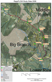
Ten monitoring sites are planned, starting in the Upper Rush River Subwatershed just above the point where the Virginia Department of Environmental Quality has designated the Rush to be an “Impaired” stream.
The study sites are shown on the map.The pilot volunteer monitoring program is made up of three components: monthly monitoring of chemical, biological, and physical parameters; semi-annual or quarterly benthic macroinvertebrate sampling; and ongoing stream buffer and health evaluations. Volunteers are invited to participate in one or more of these activities.
Data collected by RappFLOW volunteers will be used for the following purposes:
- Establish a baseline set of water quality and stream vegetative buffers data for the Rush River.
- Identify possible sources of contaminants and evaluate their solutions
- Raise awareness of water quality issues in Rappahannock County
- Identify locations on the Rush River and its tributaries to be monitored in an ongoing monitoring program to measure long-term improvements in the water quality and stream vegetative buffers.
- Provide data to the Culpeper Soil and Water Conservation District (CSWCD) to help them identify landowners that may be good candidates for cost-share incentive programs for installing BMPs (including stream vegetative buffers) and developing a land management plan.
- Incorporate the data and associated maps into RappFLOW’s Upper Thornton watershed database.
- Review and refine the protocols we use for training volunteers to make systematic observations of streams and buffer vegetation.
- Refine methods for collecting, analyzing and interpreting measures of water quality, in preparation for an ongoing monitoring program in Rappahannock County.
For more details, click here.

