How Healthy Are Our Watersheds?
Ways to Protect Our Watersheds
Stream Buffers
-Riparian Buffer & Rain Garden
-Buffer Handbook
-Sources of native plants
Upper Thornton River Watershed Study
RappFLOW is a member of the Orion Grassroots Network
People, Land and Water at the
Headwaters of the
Rappahannock River Basin
Executive Summary
This report summarizes the results of a four-year project to describe the watersheds of Rappahannock County, Virginia. It is written for landowners and residents, to assist in continuing efforts to preserve, protect, conserve, and restore water resources and watersheds of Rappahannock and neighboring counties.
Rappahannock County thus far has avoided major watershed problems that have resulted in other localities from rapid, dense development. Protecting watersheds from future degradation and vulnerability is far less costly than restoring them after damage has been done. Therefore, this study focuses primarily on factors that contribute to protecting our watersheds from future damage, as well as sources of present vulnerability.
The local government provides protection for the watersheds through its Comprehensive Land Use Plan and its enforcement of state and local ordinances including Zoning, Subdivision, Stream Buffer Protection Overlay of Zoning, Erosion & Sedimentation Control, Biosolids, Stormwater Management; and the Land Use taxation, Farmland Preservation, and Agricultural/Forestal Districts Programs.
Subwatersheds
The health and condition of a stream is a direct reflection of the health of its surrounding watershed. Nearly every subwatershed in the County drains to one of four river segments that have been designated as “impaired” by the Virginia Department of Environmental Quality. The water in those river segments has exceeded Federal standards for levels of certain bacteria. High bacteria levels are an indicator of other types of contamination. However, the subwatersheds vary in the extent to which they contribute to contamination of streams.
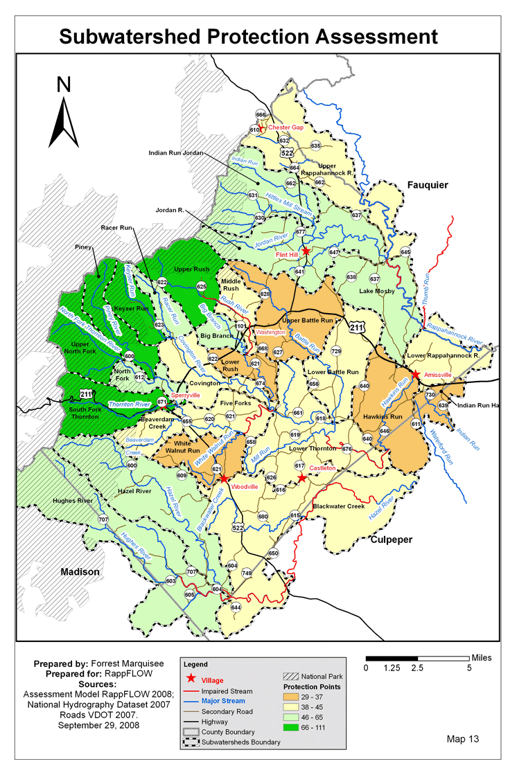
We divided the County into 26 subwatersheds, based on topography and other considerations. The main purposes for dividing into subwatersheds are to:
- assist landowners in understanding the watershed conditions in their own localities.
- identify areas that are the least well protected, so that high-priority efforts can be given to improvement in those areas by local landowners and conservation organizations.
- study in more detail smaller areas than an entire county.
Factors Used to Assess Watershed Health and Protection
We applied the following factors in a systematic way to assess and compare the extent to which subwatersheds within and adjacent to this County are protected: Shenandoah National Park; Conservation Easements; Forested Land Cover; Stream Buffer Vegetation; Zoning; and Soil Erodibility. Maps 2 – 12 show the distribution of these protection factors across the County.
The result of this model is depicted in Map 13: Subwatershed Protection Assessment. The least-protected (most vulnerable) subwatersheds are White Walnut Run, Upper Battle Run, Lower Rush, Hawkins Run, Indian Run Hazel, and Covington. The subwatersheds that rank highest (most well protected) include Upper North Fork, Piney, South Fork Thornton, Keyser Run, and Upper Rush.
Additional factors affecting the protection or vulnerability of watersheds in our particular area include future development, changing patterns of temperature and precipitation due to global climate change, over 400 miles of private roads and driveways; road/stream crossings; residential landscaping and land management practices; agricultural and forestry land management practices; sewage treatment plant effluent discharge to streams; private septic systems; and future development patterns. Of these, agricultural land management is the most significant variable that can be improved or mitigated – specifically the use of best management practices to protect stream buffer vegetation on pastures. Pastures account for over ninety percent of the bacterial contamination of the designated impaired streams.
Landowner Concerns and Values
Landowners’ greatest water-related concerns include quality of well water, adequate supply of good drinking water, and bacterial contamination of streams. The greatest threats perceived by landowners to their watershed include subdivision of land parcels, population growth, and sewage treatment plant discharges to streams. Over ninety percent of landowners support expenditures of public money on watershed protection and restoration. Groups of landowners in several subwatersheds have demonstrated strong commitment to protecting their streams through their participation in public forums and other community actions. Several non-profit organizations and volunteer groups have as part of their missions the conservation, preservation and protection of environmental, cultural, ecological or economic aspects of our watersheds.
Indicators of Water Quality and Quantity
To assess the quality of surface water in the 755 miles of streams and 540 acres of ponds in the County, there are only a few sources of data, and these provide information regarding water quality in a small sample of locations. The sources include the following:
- There are four stream segments designated 303d “Impaired” for Ecoli by the DEQ.
- Countywide, there are about 12 DEQ ambient monitoring stations, although not all are currently active. See Map 16.
- There are currently 8 locations where citizens monitor the macroinvertebrates.
- Some streams are classified by the Virginia Department of Game and Inland Fisheries as coldwater or trout streams, within subwatersheds designated by Trout Unlimited as Brook Trout Protection Area.
- RappFLOW volunteers have sampled chemical and biological water quality in selected locations, in spring 2005 and in summer 2006
- There is one USGS streamflow gage, in Laurel Mills.
- There are no groundwater monitoring stations in the county.
Further Questions
Future studies might address questions in the following areas: water quality; precipitation and stream flow; effects of climate change; groundwater patterns and trends; biological indicators; environmental services; incentives for agricultural landowners; and sustainable forestry.
Suggested Goals
Individuals, groups of landowners within subwatersheds, and other organizations may wish to consider the following goals as the most likely ways to help restore and provide greater protection for the future.
Goal 1: Increase monitoring of water quality, water quantity, and other indicators of watershed health, and make this information continually accessible to the community.
Goal 2: Increase the percentage of 100-foot riparian buffer zone that is managed to provide protection for streams, from the present 62% to 80%.
Goal 3: Increase the percentage of privately held land in easement from the present 20% to 40%.
Recommendations
- Expand existing water monitoring programs and to establish and operate new programs of data collection, analysis, and reporting beyond those currently in place through state and volunteer activities.
- Find new and additional incentives to assist farmers in implementing Best Management Practices on hayfields and pastures, in particular to improve vegetative buffers along the streams. This is likely have the most impact on increasing the protection of watersheds.
- Focus resources and priorities for watershed improvement on the least-protected subwatersheds.
Next: Introduction
Back to TOC