How Healthy Are Our Watersheds?
Ways to Protect Our Watersheds
Stream Buffers
-Riparian Buffer & Rain Garden
-Buffer Handbook
-Sources of native plants
Upper Thornton River Watershed Study
RappFLOW is a member of the Orion Grassroots Network
People, Land and Water at the
Headwaters of the
Rappahannock River Basin
5 How well protected are our watersheds?[15]
One challenge in assessing the health and protection level of our watersheds is to decide what the yardstick is. Protection compared to what? A state of nature without people? Other counties in northern Virginia?
5.1 Comparisons with an “ideal”
A perfectly protected watershed from an ecological standpoint would be a completely vegetated, highly diverse ecosystem with no human activities and land uses to interfere with nature’s processes for stormwater management and no human-created pollution to compromise the water quality or cause erosion. From a legal standpoint, there would be no threat of developing impervious surfaces like roads and rooftops. Portions of Rappahannock County subwatersheds are nearly perfectly protected, both legally and in land use, where they are inside the Shenandoah National Park.
In the model we developed for assessing Rappahannock County’s subwatersheds, a “perfectly protected” subwatershed would have 100% of its land in the Shenandoah National Park, 100% of the land cover in forest, 100% of the 100-foot stream buffers in forest cover, no land in commercial or residential zoning, and no highly erodible soils on nonforested land.
For subwatersheds that do not lie within the SNP, conservation easements can help to protect the watershed by protecting in perpetuity parcels larger than 100 acres against future subdivision and development.[16] (The easement does not necessarily require protection of stream buffer vegetation, however.)
5.2 Comparisons with poorly protected areas elsewhere
A poorly protected urban or suburban watershed would be one that has a high percentage of impervious surfaces such as parking lots, highways, residential and commercial development. In a rainstorm, polluted runoff from impervious surfaces and mowed lawns would run directly into streams, either in concrete channels or eroded streambeds. Rappahannock County has no such subwatersheds, and under current zoning and subdivision regulations and the stormwater management ordinance, it will not in future have any subwatersheds so poorly protected.[17]
A very poorly protected agricultural watershed would have dense collections of livesk, such as feedlots, very close to streams, or row crops right alongside the streams, where nutrients such as fertilizers and manure run off into the streams directly in a rainstorm. Rappahannock County does not have any agricultural subwatersheds in such a low-protection status. However, some subwatersheds have a relatively low percentage of well-vegetated stream buffer area.
5.3 How did we quantify the protection level of subwatersheds in the model?
We used the six factors listed above in conducting a systematic assessment across all subwatersheds in the county, as shown in Maps 1 through 12. We used computer-based data and spatial analysis techniques generally referred to as GIS, to compute the percentage of the land area of the subwatershed that is protected by a particular factor. We assigned points to each subwatershed for each of the six factors, based on those percentages. For example, for conservation easements we calculated the number of acres of VOF easement[18] in each subwatershed, and then divided that by the total number of acres (outside the SNP) in the subwatershed. This resulted in a “Percent VOF” figure. We converted the percentages to points for each subwatershed. We then assigned weights, or relative importance, to each of these six factors. SNP points are multiplied by 4; VOF points by 3; Forested stream buffer points by 2.
(SNP points * 4) + (VOF points * 3) + (Forested Stream Buffer points*2) + Forest Cover Points + Zoning Protection Points + Erodible Soils points = Total Score
5.4 Comparing the subwatersheds’ protection levels
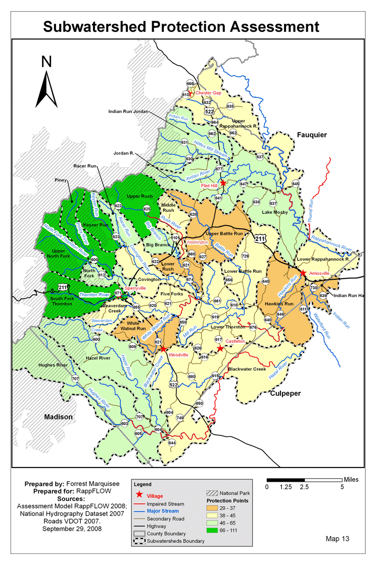
Chart 2 shows the list of subwatersheds and their total protection points according to this model. The three lowest-scoring subwatersheds are White Walnut Run, Upper Battle Run, and Lower Rush. Sections 10-12 below provide more detailed descriptions and maps of these three subwatersheds.
Subwatershed |
Soil Points |
Zoning Points |
08VOF Points |
SNP Points |
Forest Points |
Forested Stream Buffers |
Total Protection Points |
Upper North Fork[19] |
10 |
10 |
7 |
10 |
10 |
10 |
111 |
Piney |
10 |
10 |
0 |
7 |
10 |
10 |
78 |
South Fork Thornton |
10 |
9 |
0 |
8 |
9 |
8 |
76 |
Upper Rush |
10 |
10 |
2 |
6 |
9 |
8 |
75 |
Keyser Run |
10 |
10 |
1 |
6 |
10 |
9 |
75 |
Indian Run Jordan |
9 |
10 |
4 |
3 |
8 |
7 |
65 |
Hughes River |
9 |
10 |
1 |
4 |
7 |
5 |
55 |
Hazel River |
9 |
10 |
1 |
3 |
7 |
6 |
53 |
Big Branch |
9 |
9 |
6 |
0 |
6 |
5 |
52 |
Racer Run |
9 |
10 |
2 |
0 |
9 |
8 |
50 |
Jordan R. |
8 |
10 |
3 |
1 |
6 |
6 |
49 |
North Fork |
9 |
10 |
1 |
2 |
7 |
6 |
49 |
Lake Mosby |
9 |
10 |
2 |
0 |
7 |
8 |
48 |
Beaverdam Creek |
8 |
10 |
1 |
2 |
6 |
5 |
45 |
Upper Rappahannock R. |
9 |
9 |
2 |
0 |
7 |
7 |
45 |
Lower Thornton |
8 |
10 |
2 |
0 |
6 |
7 |
44 |
Lower Battle Run |
8 |
10 |
3 |
0 |
5 |
5 |
42 |
Lower Rappahannock R. |
9 |
9 |
0 |
0 |
7 |
8 |
41 |
Middle Rush |
8 |
9 |
2 |
1 |
5 |
4 |
40 |
Five Forks |
7 |
10 |
2 |
0 |
5 |
6 |
40 |
Blackwater Creek |
9 |
10 |
0 |
0 |
7 |
7 |
40 |
Covington |
8 |
10 |
2 |
0 |
5 |
5 |
39 |
Indian Run Hazel |
10 |
9 |
0 |
0 |
6 |
6 |
37 |
Hawkins Run |
9 |
10 |
0 |
0 |
5 |
6 |
36 |
Lower Rush |
8 |
9 |
1 |
0 |
5 |
5 |
35 |
Upper Battle Run |
7 |
10 |
2 |
0 |
5 |
3 |
34 |
White Walnut Run |
6 |
10 |
1 |
0 |
4 |
3 |
29 |
Table 2: Subwatershed Protection Points
5.5 Using the subwatershed protection map
Map 13 shows the results of the subwatershed protection analysis. The subwatersheds shown in orange are those receiving the lowest number of “protection points.” The subwatersheds colored yellow are next-to-lowest. These are the areas of the county where highest priority should be given to improvement of stream buffer vegetation and increased easement protection as discussed in the Goals section below. More details for the Lower Rush, White Walnut Run, and Upper Battle Run are provided in later sections of this report. To see more detailed maps of your own subwatershed, please click on “My Subwatershed.”
Next: Values, concerns, and
knowledge of those who own or use the land
Back to TOC