How Healthy Are Our Watersheds?
Ways to Protect Our Watersheds
Stream Buffers
-Riparian Buffer & Rain Garden
-Buffer Handbook
-Sources of native plants
Upper Thornton River Watershed Study
RappFLOW is a member of the Orion Grassroots Network
People, Land and Water at the
Headwaters of the
Rappahannock River Basin
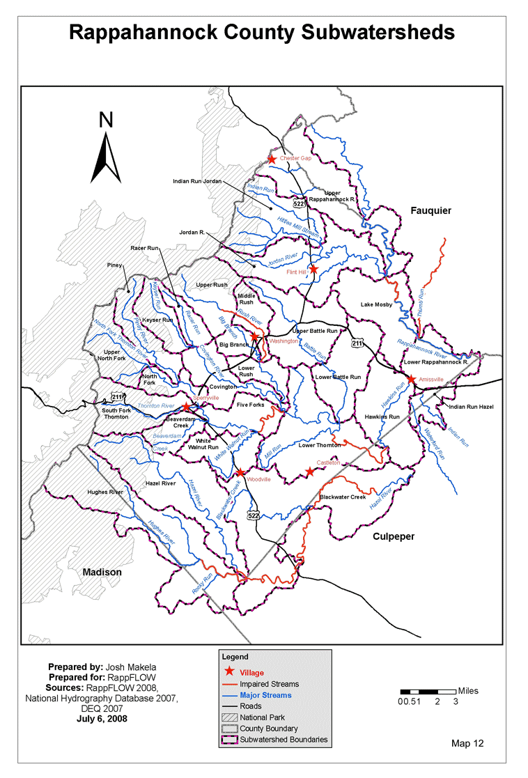
4 What and Where are the County’s Subwatersheds?
Following recommendations from the Center for Watershed Protectionendnotes.html[13] we divided the County into 26 subwatersheds.[14]All raindrops falling on land within a subwatershed drain to a common point. Often that point is where the main stream of the subwatershed joins a larger stream. The main purposes for dividing the overall county into smaller subwatersheds are to:
- assist landowners in understanding the watershed conditions in their own localities.
- identify areas that are the least well protected, so that priority efforts by the local landowners and conservation organizations can be given to improvement in those areas.
- look in more detail at factors that affect the health of the watersheds, within a smaller area than an entire county.
Each subwatershed is named after the major stream that flows through that area. Table 1 lists the 26 subwatersheds, their land areas, and stream miles.
Subwatershed Name |
Acres |
Square Miles |
Stream Miles |
Beaverdam Creek |
3101.42 |
4.85 |
14.95 |
Big Branch |
2015.77 |
3.15 |
9.11 |
Blackwater Creek |
24036.04 |
37.56 |
64.15 |
Covington |
5554.93 |
8.68 |
30.31 |
Five Forks |
4688.22 |
7.33 |
22.41 |
Hawkins Run |
8940.40 |
13.97 |
34.37 |
Hazel River |
15111.36 |
23.61 |
67.51 |
Hughes River |
19512.22 |
30.49 |
42.10 |
Indian Run Hazel |
2287.81 |
3.57 |
12.35 |
Indian Run Jordan |
9324.21 |
14.57 |
35.04 |
Jordan R. |
12583.34 |
19.66 |
72.35 |
Keyser Run |
3816.94 |
5.96 |
11.59 |
Lake Mosby |
8703.29 |
13.60 |
36.54 |
Lower Battle Run |
7761.37 |
12.13 |
37.21 |
Lower Rappahannock R. |
5619.81 |
8.78 |
21.61 |
Lower Rush |
2855.35 |
4.46 |
23.02 |
Lower Thornton |
13852.96 |
21.65 |
67.93 |
Middle Rush |
3128.81 |
4.89 |
23.00 |
North Fork |
2873.24 |
4.49 |
24.20 |
Piney |
4780.44 |
7.47 |
14.17 |
Racer Run |
2468.74 |
3.86 |
8.34 |
South Fork Thornton |
6782.88 |
10.60 |
18.80 |
Upper Battle Run |
9769.23 |
15.26 |
40.05 |
Upper North Fork |
5753.17 |
8.99 |
16.33 |
Upper Rappahannock R. |
13090.44 |
20.45 |
46.66 |
Upper Rush |
6766.90 |
10.57 |
28.07 |
White Walnut Run |
5038.70 |
7.87 |
21.94 |
Table 1: Subwatershed Names, Areas and Stream Miles
As shown on Map 12: Subwatersheds, portions of some subwatersheds lie in Fauquier, Culpeper, and Madison counties.
Next: How well protected are our watersheds?
Back to TOC